Download Esri.EADE105.PracticeTest.2019-10-17.36q.tqb
| Vendor: | Esri |
| Exam Code: | EADE105 |
| Exam Name: | ArcGIS Desktop Entry 10.5 |
| Date: | Oct 17, 2019 |
| File Size: | 712 KB |
Demo Questions
Question 1
Refer to the exhibit.
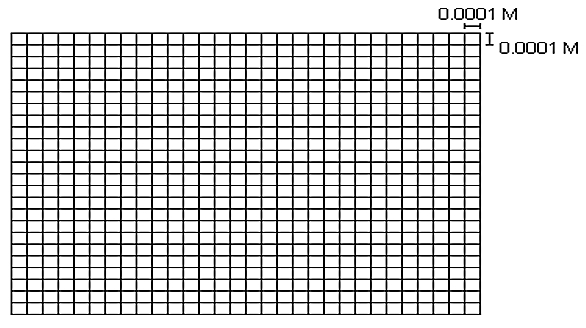
The exhibit below provides a conceptual view of a coordinate grid onto which all coordinate values snap to the grid mesh. The grid covers the extent of each dataset. An ArcGIS user is creating a new feature class, and needs to increase the numeric precision used to store the coordinate values.
When modified, which of the following will increase the numeric precision used to store the coordinate values?
- X,Y Tolerance
- Z value
- M Value
- X,Y Resolution
Correct answer: D
Explanation:
Reference: http://webhelp.esri.com/arcgisdesktop/9.2/index.cfm?TopicName=Feature_class_basics Reference: http://webhelp.esri.com/arcgisdesktop/9.2/index.cfm?TopicName=Feature_class_basics
Question 2
A biologist must go into the field and record locations of every site that currently has standing water with mosquito larvae.
Which application should the biologist use?
- ArcGIS Online
- ArcGIS Pro
- Navigator for ArcGIS
- Collector for ArcGIS
Correct answer: D
Explanation:
Reference: https://doc.arcgis.com/en/collector-classic/android/create-maps/track-where-collectors-went.htm Reference: https://doc.arcgis.com/en/collector-classic/android/create-maps/track-where-collectors-went.htm
Question 3
A GIS user has an address and must display the location of the address as a point on the map. The user has a general idea of where the address is located but needs a precise result
How should the user efficiently perform this task in ArcMap?
- Type the full address in the search field of the Geocoding Toolbar, and press Enter
- Zoom in to the city, pan to the street. and use the Address Inspector on the Geocoding Toolbar
- Open the Go To XY tool and search the full address
- Open the Geocode Addresses tool from the Geocoding Toolbar and search the full address
Correct answer: C